Driving the road to Cilaos and its 400 bends
What the map doesn’t tell you
Cilaos looks close on a map. It sits maybe 35 kilometres from the coast at Saint-Louis, and on paper that reads like a half-hour drive anywhere else. It isn’t. The RN5 climbs from sea level to around 1,200 metres through a corridor cut into basalt cliffs, and it does it in a series of bends that the road itself has made famous: around 400 of them, most of them tight, many of them signed with their own number so you can watch the count climb as you do.
I mention this first because it’s the single most useful thing I can tell you before you rent a car for this trip: forget kilometres, think in minutes. Thirty-five kilometres on the driving in Réunion Island guide’s flat coastal stretches might take twenty-five minutes. Thirty-five kilometres up to Cilaos takes close to an hour, without stopping. Build your day around that number, not the one on the map.
Where it starts, and what the first bends feel like
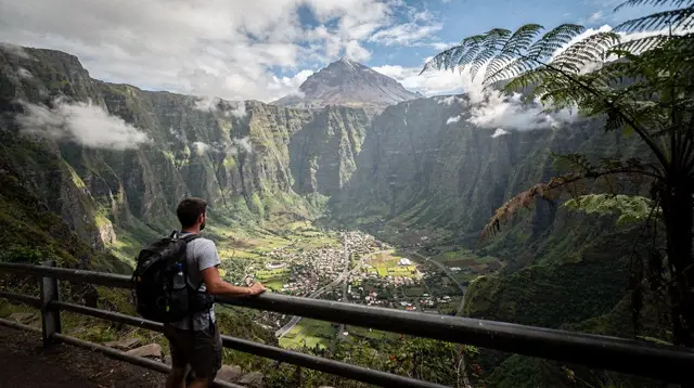
The climb begins just past Saint-Louis, on the edge of the south, and announces itself almost immediately: the road narrows, the guardrails appear, and the valley of the Bras de Cilaos opens up below you on the right. The first kilometres are the steepest in feel, if not always in gradient, because you’re still adjusting to a rhythm of brake, turn, accelerate out, brake again that doesn’t really let up until you reach the plateau at the top.
There’s no way to drive this fast, and no reason to try. Locals who make the trip daily, for work or to visit family, know it well enough to keep a steady pace through blind corners, and they use their horn on the tightest ones, a habit worth copying rather than finding aggressive. If you’re renting a car specifically for this drive, a compact model is genuinely easier to place on the road than anything wider; see renting a car in Réunion Island if you haven’t booked yet.
The middle stretch: tunnels, drops, and the numbered bends
Past the initial climb, the road settles into its defining character: a long sequence of hairpins carved along the cliff face, several short tunnels, and viewpoints where a shoulder wide enough for two or three cars lets you pull over safely. I stopped at two of them on my way up, mostly because my knuckles needed the break as much as the view did. The drop on one side is real and close enough that passengers who don’t love heights should know what they’re in for.
This is also where the numbered bend markers become almost a game, if you’re not the one driving. Somewhere past bend 200 you start to believe the “400” figure isn’t a tourist exaggeration; it’s closer to a literal count of what the road engineers needed to gain the altitude without switching to something steeper. The road was built this way for a reason, and once you’re in the middle of it, the reason is obvious: there’s no shortcut through a cliff.
Cloud cover changes fast up here. It can be clear at Saint-Louis and socked in by fog three-quarters of the way up, especially from mid-morning onward. If you’re driving early, that’s less of an issue; leave it until noon and you may spend the last stretch in a fine drizzle with visibility down to the next bend.
Timing the drive: when to go, and when not to
Early morning is the easiest window, both for light and for traffic: fewer delivery trucks, less cloud, and cooler air if you’re driving with the windows down. I’d avoid starting the climb much after 10am if you can help it, for the same reason the Maido viewpoint and the volcano road reward an early start — cloud tends to build through the morning across the island’s interior, and Cilaos is no exception.
Rain changes everything on this road. After heavy downpours, sections of the RN5 can close for rockfall or landslide clearance, sometimes for hours, occasionally longer during the cyclone season between November and April. If the forecast looks unsettled, check conditions before you commit to the day, and have a plan B rather than pushing through weather you can’t see clearly ahead of.
If you’d rather not drive it at all, a guided day trip from Saint-Gilles does the climb for you, which some passengers prefer purely to enjoy the view instead of gripping the wheel. It’s a legitimate way to see Cilaos without owning the drive yourself, and one worth considering if anyone in your group gets carsick on switchbacks.
What waits at the top, briefly
I’m not going to turn this into a guide to Cilaos itself — that’s its own page, and the cirque deserves more than a paragraph tacked onto a driving story. But it’s worth saying what the climb buys you: a mountain town built around thermal springs, some of the island’s best canyoning, lentil fields, and the trailhead for the Piton des Neiges summit hike, the island’s highest point. For a wider sense of what’s up there once you arrive, things to do in Cilaos covers it properly, and if you’re weighing Cilaos against the greener, more accessible Salazie, the Cilaos versus Salazie comparison lays out the real differences.
If the road itself sounds like enough of a challenge for one trip, plenty of visitors get their aerial view of the cirques a different way: a microlight flight over Réunion Island crosses the same terrain in minutes rather than an hour of hairpins, and a few operators run it out of the west coast alongside a tandem paragliding flight over the bay of Saint-Leu. Neither replaces the drive if you’re actually staying in Cilaos, but they’re a fair trade if switchbacks aren’t your thing. On a clear morning back down on the coast, a dolphin and whale watching trip out of Saint-Gilles is a good, flatter way to spend the rest of the day once your knuckles have recovered.
The honest summary
The road to Cilaos is not a scenic detour you squeeze into a bigger loop. Treat it as a destination in itself for the hour it takes, keep your expectations to minutes rather than kilometres, start early if you can, and check conditions after rain. Compare it against the coastal alternatives covered in the new coastal road explained, and if you want a broader sense of what catches out first-time drivers on the island, travel mistakes to avoid in Réunion Island is worth a read before you set off. Done at the right pace, on the right morning, the drive itself becomes one of the better parts of the trip, not just the price of admission for the cirque at the top. It also fits naturally into a longer loop — see three cirques in four days if Cilaos is one stop among several — and pairs well with a broader look at the best hikes in Réunion Island once you’re up there.
Driving to Cilaos: quick facts
| Detail | What to expect |
|---|---|
| Starting point | Saint-Louis, on the edge of the south |
| Number of bends | Around 400, numbered along the route |
| Driving time | About an hour, non-stop |
| Elevation gain | From sea level to roughly 1,200 metres |
| Vehicle needed | Standard rental car; four-wheel drive not required |
| Best time to go | Early morning, before cloud builds |
| Risk to watch for | Road closures after heavy rain, especially November to April |
Getting around Réunion tours on GetYourGuide
Verified deep-linked GetYourGuide tours. Book through these links and we earn a small commission at no cost to you.
GetYourGuide does not provide a product photo for this activity — the image shows the meeting point, photographed by us.