Driving in Réunion Island: what the roads are actually like
Is driving in Réunion Island difficult?
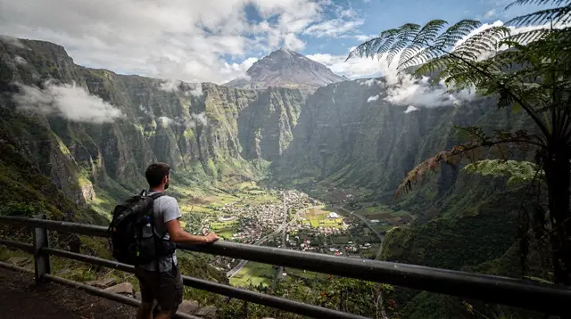
The coastal roads are easy and drive like mainland France, but the mountain roads to Cilaos, the volcano, and the Maido are narrow, steep, and full of hairpin bends. Distances in kilometres are misleading there; plan by travel time, not distance, and start early to beat fog and traffic.
What it actually feels like behind the wheel
If you already have a car, whether it is your own rental sitting outside the gîte or a set of keys just handed over at the counter, this page is about the road itself, not about which company to book with or what paperwork to bring. For the practical side of choosing and booking a car, see renting a car in Réunion Island. For a wider picture of getting around without focusing only on driving, see getting around Réunion Island.
The short version: the coast drives like ordinary provincial France, and the interior does not drive like anywhere most visitors have driven before. Both halves of that sentence matter, because the contrast is what catches people out. A driver who has only ever seen the flat, fast coastal stretch between Saint-Gilles and Saint-Paul can be genuinely unprepared for what the road to Cilaos demands twenty minutes later.
Réunion Island keeps right, the same as mainland France, with the same priority-to-the-right defaults in towns and the same speed limits: 50 km/h in built-up areas, 80-90 km/h on open rural roads depending on signage, 110 km/h on the short dual-carriageway sections. None of that is unusual for anyone who has driven in France before. What is unusual is the terrain the road network has to cross.
The three roads that define mountain driving here
The road to Cilaos: roughly 400 bends from Saint-Louis
The RN5 from Saint-Louis to Cilaos is the single most talked-about road on the island, and the reputation is earned. It gains around 1,200 metres of altitude over roughly 35 kilometres, and it does it through a continuous sequence of hairpins carved into the gorge of the Bras de Cilaos, with drops on one side and rock face on the other for most of the way. Locals count the bends at close to 400, and whether the true number is 380 or 420 barely matters at the wheel: what matters is that first or second gear does most of the work, that overtaking is rarely possible, and that a driver unused to sustained switchbacks should expect to feel it in their stomach before the top.
Budget around an hour for the climb without stops. Behind a delivery truck, a cyclist, or a weekend convoy of tour minivans, it can take noticeably longer. There is nowhere to rush this road, and nowhere it rewards trying. Day-trip options that include this drive without you doing it yourself are covered in Cilaos day trip from Saint-Gilles.
The road to the volcano: exposed, and closed when it needs to be
From Bourg-Murat, on the Plaine des Cafres, the road to Piton de la Fournaise climbs through forest, then opens onto the lunar expanse of the Plaine des Sables before reaching the Pas de Bellecombe car park at around 2,311 metres. The road surface itself is in reasonable condition and less bend-for-bend intense than Cilaos, but it is a long, single, exposed run with no fuel station, no shop, and very little shelter along the way. Check a full tank before leaving the coast.
The practical risk here is not the road surface, it is timing. Cloud typically builds from mid-morning and can reduce visibility on the Plaine des Sables to a few metres within twenty minutes. Leave early, ideally before 7am, to have any real chance of a clear view at the top, and treat a late-morning departure as a coin toss on visibility rather than a plan. Whether the volcano’s crater trail itself is open on a given day is a separate question of préfecture closures during eruption alerts; see Piton de la Fournaise volcano tours for that side of it. This page is only about getting the car there safely.
The road to the Maido: a long, steady climb above Mafate
The road up to the Maido belvedere, above Saint-Paul on the west coast, is well sealed and well maintained, but it climbs almost 2,200 metres from the coast in a continuous series of switchbacks through cryptomeria forest. It is not as narrow or as intimidating as Cilaos, but it is long, and most visitors drive it in the dark to catch sunrise over Mafate before the clouds rise, which changes the character of the drive considerably: same bends, no visibility of the drop, headlight glare from oncoming cars on a road with almost no lay-bys. Driving it once in daylight first, if the schedule allows, makes the pre-dawn version far less stressful.
With hairpins on the Cilaos road and an early start for the volcano, the car matters more here than on most islands. Check the gearbox type, since an automatic takes some strain out of the climb, and confirm the pick-up opens early enough for a departure before 7am with a full tank. Read the fuel policy and the damage terms carefully, then compare cars with Localrent for your dates.
The rule that matters more than any single road: kilometres are not minutes
Across the whole interior of the island, the flat-road habit of converting kilometres into minutes at some fixed speed simply does not apply. Thirty kilometres on the coast might take 25 minutes. Thirty kilometres into the Hauts can take an hour and a half. The bends, the gradient, the width of the carriageway, and the traffic mix (tour vans, cyclists, agricultural vehicles) all eat into average speed far more than distance alone suggests.
The practical fix is to always ask for or estimate a travel time, never a distance, when planning a day that includes any mountain road. A rough sense of what to expect:
| Route | Distance | Honest travel time |
|---|---|---|
| Saint-Louis to Cilaos | ~35 km | ~1 hour, more with traffic |
| Bourg-Murat to Pas de Bellecombe | ~25 km | ~40-50 minutes |
| Saint-Paul to the Maido | ~35 km | ~1 hour to 1h15 |
| Saint-André to Hell-Bourg (Salazie) | ~35 km | ~50 minutes |
| Saint-Gilles to Saint-Denis (coastal road) | ~25 km | 30 minutes off-peak, 45-60+ at rush hour |
Treat this table as a planning aid, not a promise: a landslide closure, a breakdown ahead of you, or a slow tour convoy can add real time to any of these.
Coastal traffic: Saint-Denis and the route du littoral
The interior gets the dramatic reputation, but the most reliably frustrating traffic on the island is mundane: the commute into and out of Saint-Denis and along the coastal road (route du littoral) connecting it to the west coast. On weekday mornings, roughly 6:30 to 8:30am, and again in the evening from about 4:30 to 6:30pm, this stretch backs up like any commuter road serving a capital of over 100,000 people. Outside those windows it moves freely.
If a transfer to or from Roland-Garros airport falls inside a rush-hour window, add a genuine margin, not a token five minutes. The route du littoral has also been progressively rebuilt in recent years as a new sea viaduct, which has changed its exact alignment and lane count more than once; treat any older printed map of this road with caution and lean on live signage and navigation apps for the current layout.
Fog on the heights: a fact of the schedule, not bad luck
Cloud rising through the morning is not an occasional inconvenience on Réunion, it is close to a daily pattern on the volcano road and around the Maido, and frequent in the cirques as well. Moist air pushed up from the coast condenses as it climbs and cools, typically thickening from mid-to-late morning. A driver who leaves the coast at 9am for the volcano is not unlucky to find themselves in cloud by 10:30; they are simply on the normal schedule for it.
The only reliable countermeasure is departure time. An early start, before sunrise for the Maido and by 6:30-7am for the volcano road, is not a suggestion for a nicer photo, it is the difference between seeing the landscape and driving through white. Fog on these roads also cuts visibility for the drive itself, not just the view, so slow down and use fog lights if the car has them.
What the coastal and lowland roads are actually like
It would be misleading to describe only the mountain roads and leave the impression that all driving here is demanding. The coastal ring, from Saint-Denis around through Saint-Gilles, Saint-Leu, the Étang-Salé stretch, and on to Saint-Pierre, is largely dual carriageway or good single carriageway, well signed, and unremarkable to drive by day. The East coast road toward Sainte-Rose and the Grand Brûlé is narrower in places and worth slowing for regardless, since it crosses old lava flows and passes through small villages, but it presents nothing like the switchback intensity of Cilaos or the volcano.
Fuel, phone signal, and other practical realities
Fuel stations thin out fast once a road leaves the coast; fill up before Bourg-Murat, before Saint-Louis if heading to Cilaos, and before Saint-Paul if heading up to the Maido. Mobile signal is patchy to absent on the Plaine des Sables and in parts of the cirques, so download offline maps in advance rather than relying on live data at the moment it matters most. EU roaming plans work normally on the coast but should not be counted on above the tree line.
Hairpin bends mean short sightlines, so a light tap of the horn before a blind bend on a narrow mountain stretch is standard local practice, not aggression. Cyclists training on the volcano and Maido roads are common, especially at weekends and early morning; give them a wide berth on the bends where there is no shoulder.
Putting the driving in context with the rest of a trip
None of this is a reason to avoid the interior; it is a reason to build a realistic schedule around it. A full day set aside for Cilaos, a pre-dawn departure for the Maido or the volcano, and a coastal transfer routed around the Saint-Denis rush hour will cover the great majority of what catches first-time drivers out. For those who would rather see the cirques and the volcano without doing the driving themselves, a guided option such as the multi-day complete tour of the island covers the same ground with someone else at the wheel, and a helicopter flight over the cirques and volcano or a microlight flight over the island shows the same landscape from above without a single hairpin bend. For something more active than a road trip but still road-based, a quad or buggy outing above Saint-Gilles is a different way to feel the terrain at a slower, more deliberate pace.
For a fuller sense of how much ground to plan for across the whole trip, see how many days in Réunion Island, and for the mistakes that trip up first-time drivers most often beyond the road itself, see Réunion Island travel mistakes to avoid.
Driving in Réunion Island: frequently asked questions
Do you drive on the right or the left in Réunion Island?
On the right, exactly as in mainland France. Road signs, priority rules, and speed limits follow the French Code de la route.
How long does the road to Cilaos really take?
From Saint-Louis, the RN5 climbs through roughly 400 bends to reach Cilaos. The distance is short on a map, but the drive takes about an hour without stops, longer behind a truck, a cyclist convoy, or a caravan of tour vans on a weekend.
Is the road to the volcano dangerous?
It is not technically dangerous if driven carefully, but it is exposed: single carriageway, no fuel or shelter between Bourg-Murat and the Pas de Bellecombe car park, and cloud that regularly rolls in by mid-morning and cuts visibility to a few metres.
What is the traffic like around Saint-Denis?
Saint-Denis and the coastal road (route du littoral) linking it to the west coast see real rush-hour congestion on weekday mornings and evenings, roughly 6:30-8:30am and 4:30-6:30pm. Outside those windows traffic is light.
Is the Maido road difficult to drive?
It is a good, sealed road, but it climbs continuously with tight switchbacks over roughly 2,200 metres of elevation gain from Saint-Paul. It is straightforward in daylight and dry weather, less so in the pre-dawn dark that a sunrise visit requires.
Do I need a 4x4 to drive in Réunion Island?
No. Every road described here, including Cilaos, Salazie, and the volcano, is sealed and accessible in a standard rental car. A 4x4 changes nothing on these routes; it matters only for a handful of unsealed forestry tracks that most visitors never use.
Can I reach Mafate by car?
No road reaches Mafate. It is entered on foot only, from trailheads such as the Maido, the Col des Boeufs, or Dos d’Ane. Any car journey toward Mafate ends at one of these trailheads, not inside the cirque.
Getting around Réunion tours on GetYourGuide
Verified deep-linked GetYourGuide tours. Book through these links and we earn a small commission at no cost to you.
GetYourGuide does not provide a product photo for this activity — the image shows the meeting point, photographed by us.