Hiking in Mafate: planning guide
How do you get to Mafate?
Only on foot. There is no road into Mafate, so you walk in from trailheads such as the Maïdo, the col des Boeufs, or the rivière des Galets. Helicopters fly in supplies for the hamlets, not visitors. Most trips take 1 to 3 days of walking with a night or two in a gîte.
No road leads to Mafate
Of the three cirques carved into the heart of Réunion — Cilaos, Salazie, and Mafate — only Mafate has never had a road built into it. The terrain, a maze of ravines below Le Maïdo and the Piton des Neiges massif, made it too steep and too unstable to engineer one. That single fact should shape how you plan a visit: Mafate is not a place you drive to and walk around for an afternoon. It is a place you walk into, sleep in, and walk back out of, on a schedule set by trails rather than roads.
This guide treats Mafate as what it is: a logistics problem before it is a scenic one. Get the trailhead, the days, and the gîte booking right, and the cirque delivers some of the emptiest, quietest hiking in the western Indian Ocean. Get any of those wrong and you end up turned back at a col with no bed for the night.
How people actually get in
There is no vehicle access of any kind inside Mafate — no road, no track passable by car or scooter, nothing. The cirque is reached exclusively on foot, from a handful of trailheads around its rim:
- Le Maïdo (around 2,200 m, above Saint-Paul): the classic descent into La Nouvelle, roughly 3 to 4 hours down a steep, well-used path. Popular because it pairs with the Maïdo viewpoint, but the climb back out at the end of a trip is long.
- Col des Boeufs (above Salazie): the most direct route into La Nouvelle from the east, around 2 hours of walking, and the trailhead most gîte-keepers recommend for a first visit.
- Rivière des Galets (lower cirque, near Deux Bras): the access point for the lower hamlets — Sans Souci, Grand Place, Aurère — reached from the coast near Le Port rather than from altitude.
- Dos d’Âne: a village on the cirque’s western rim with its own descent toward the lower hamlets, used less by first-time visitors but useful for a one-way itinerary.
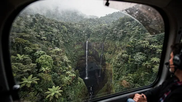
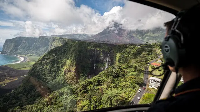
Helicopters do fly over and into Mafate daily, but not for tourists. They resupply the small shops and gîtes in each hamlet with everything from gas bottles to building materials, since nothing else can reach them. A sightseeing flight from Saint-Gilles will fly you over the cirque’s rim and its waterfalls, which is a genuinely good way to understand the terrain before or after a trek, but it lands back at the airfield — it does not drop hikers off inside Mafate. If a guide or a site implies otherwise, treat that as wrong.
a scenic helicopter flight from Saint-Gilles that traces the rim of Mafate and its waterfalls before or after the walk gives a sense of scale that the trail itself, deep in the ravines, does not.
The hamlets: where people actually live and sleep
Around 700 people live inside Mafate year-round, spread across a dozen hamlets (îlets) with no road, no car, and until relatively recently no mains electricity in some of them. Knowing the hamlets by name helps you read a gîte-keeper’s directions and plan a realistic route:
| Hamlet | Rough position | Typical use for hikers |
|---|---|---|
| La Nouvelle | Upper cirque, below the Maïdo and col des Boeufs | Most common first or last night; largest choice of gîtes |
| Marla | Upper cirque, toward Cilaos side | Second night on a 2- to 3-day loop; cooler, more exposed |
| Roche Plate | Central cirque | Quieter stop, good base for a longer traverse |
| Grand Place | Lower cirque | On the route toward the rivière des Galets exit |
| Aurère | Lower cirque, western rim | Reached via Dos d’Âne; less visited, good for a one-way route |
None of these are villages with shops, fuel, or transport in the way a coastal town is. They are clusters of a few dozen homes and gîtes, connected to each other and to the rim only by footpaths.
Planning it in days of walking, not kilometres
Distances on a map are close to meaningless in Mafate; what matters is the climbing and descending between ravines. Plan by days, not kilometres:
- 1 day (in and out): Maïdo down to La Nouvelle and back up the same day. Long and tiring — around 6 to 7 hours of walking with real elevation change — and it leaves no time to explore. Most hikers who do this regret not staying the night.
- 2 days / 1 night: walk in via the col des Boeufs or the Maïdo, sleep at La Nouvelle, walk out the following day by a different trailhead. A realistic introduction to the cirque.
- 3 days / 2 nights: the itinerary most gîte-keepers recommend for a first real visit — for example col des Boeufs to La Nouvelle, La Nouvelle to Marla or Roche Plate, then out via the Maïdo or rivière des Galets. This is enough time to feel the cirque’s rhythm rather than rush through it.
Longer traverses exist and link Mafate to Cilaos or Salazie over several more days, but they call for good fitness, proper gear, and, for most visitors, a guide. Treat 1 to 3 days as the range for a standard Mafate visit and build outward from there only with experience.
Booking the gîtes: the part that cannot be improvised
This is the detail that makes or breaks a Mafate trip. There are no hotels inside the cirque — only family-run gîtes, most with dormitory-style rooms and a set evening meal. Beds are limited: a hamlet like La Nouvelle has more capacity than Marla or Roche Plate, but none of them can absorb a surge of unbooked arrivals.
Book directly with the gîte, by phone or through the tourist office, and do it well before you go — weeks ahead for the austral winter (May to October), when clear, dry weather brings the most walkers, and especially around French school holidays. Confirm whether dinner and breakfast are included, since carrying multi-day food into the cirque is neither necessary nor common practice. If a gîte is full, the answer is to book a different hamlet or shift your dates, not to arrive and hope. Walking into Mafate at dusk without a confirmed bed is not a plan; it is how people end up spending an uncomfortable night with no shelter.
Cash is worth carrying, since card payment is unreliable this far from the coast.
When to go
Réunion’s seasons run opposite to Europe’s. The austral winter, May to October, is dry and cooler at altitude — the best window for Mafate, with firmer trails and clearer views, though mornings can still bring mist that burns off by mid-morning. The austral summer, November to April, is Réunion’s cyclone season: heavy rain can close trails with no warning, ravine crossings become dangerous, and gîtes may cancel bookings for safety. Always check trail status with the ONF before setting out, whatever the season, since a closure after heavy rain can affect any trailhead with no notice.
What to carry
- Sturdy hiking boots with grip; the descents are steep, loose in places, and hard on ankles.
- A rain layer and a warm layer even in the dry season — nights in the upper hamlets get cool, and Réunion’s weather changes fast.
- Cash for gîtes and the small hamlet shops.
- A paper map or offline GPS track; phone signal is patchy to absent in the ravines.
- Enough water for each stage — hamlets have taps, but not always between them.
- A headlamp, in case a stage runs longer than planned.
Pairing Mafate with the rest of the island
Mafate stands apart from Réunion’s other big hikes. The Piton des Neiges summit climb, covered separately in our Piton des Neiges summit hike guide, starts from Cilaos, not Mafate, and is a different kind of trip: one long push to a sunrise summit rather than a multi-day traverse. Canyoning and the cirque’s other adventure activities are their own subject too — see our adventure activities in Réunion guide for that side of things.
If Mafate is your only multi-day hike on the island, build a short buffer either side of it: a rest day in Saint-Gilles or Saint-Leu before you start, and a slow day after you climb back out, since the descents leave most people’s legs stiff for a day or two. A gentle, sit-down way to use that rest day is a dolphin and whale watching trip out of Saint-Gilles-les-Bains, which asks nothing of legs that are still recovering from the descent.
For travellers weighing up how Mafate fits into a wider trip, our best hikes in Réunion Island guide ranks it against Cilaos and Salazie day walks, and the three cirques in four days itinerary shows one way to combine all three without overreaching. Anyone still deciding between a guided or independent trek can also check Maïdo and Mafate guided hikes for what a local guide adds on unfamiliar trails. If Mafate ends up as one stop within a fuller island trip rather than its own dedicated visit, a multi-stage tour covering Réunion in 13 steps is one way to see the cirques alongside the coast without planning every leg yourself.
Getting to the trailheads
None of Mafate’s trailheads sit inside a town, so factor in the drive before you factor in the walk. The Maïdo trailhead is roughly an hour by car from Saint-Gilles, climbing through the Hauts de l’Ouest — allow extra time, since cloud often rolls in from mid-morning. The col des Boeufs trailhead is reached via Salazie and Hell-Bourg, itself a scenic but winding drive. Renting a car is close to essential for reaching either one on your own schedule; see our driving in Réunion Island guide for what the mountain roads actually involve.
A realistic Mafate itinerary
For a first visit, this 3-day structure is close to what most gîtes recommend:
| Day | Route | Notes |
|---|---|---|
| Day 1 | Col des Boeufs to La Nouvelle | Around 2 hours’ walk; arrive early afternoon, explore the hamlet |
| Day 2 | La Nouvelle to Marla or Roche Plate | 3 to 5 hours depending on route; steep in sections |
| Day 3 | Out via the Maïdo or rivière des Galets | Long climb or descent; arrange a car or transfer at the trailhead in advance |
Whichever route you choose, confirm it with the gîte-keeper when you book — they know current trail conditions better than any map, and Mafate’s paths do occasionally shift after heavy rain.
Mafate hiking: questions travellers ask
Is there really no road into Mafate?
Correct. Mafate is the only cirque in Réunion with no road at all. Every hamlet is reached on foot, and helicopters are used to resupply shops and gîtes, not to carry hikers in or out.
Can I take a helicopter into Mafate instead of walking?
No scheduled service does this. Helicopters serve the cirque for freight and, occasionally, medical evacuation. Sightseeing flights fly over Mafate but land at the departure airfield, not inside the cirque.
What are the main trailheads for Mafate?
The Maïdo (above the west coast, steep descent to La Nouvelle), the col des Boeufs (above Salazie, the most direct route to La Nouvelle), and the rivière des Galets in the lower cirque near Deux Bras and Sans Souci.
How many days do I need for Mafate?
One night is enough to see a single hamlet such as La Nouvelle. A 2-day loop lets you cross the cirque, and a 3-day trek covers several hamlets, for example La Nouvelle, Marla, and Roche Plate, without rushing.
Do I need to book gîtes in advance?
Yes, always. Mafate has no hotels and few beds. Gîtes fill up weeks ahead in the austral winter (May to October), and turning up without a booking can mean sleeping outside.
Is Mafate hiking difficult?
The trails are well marked but steep, with long descents and climbs between ravines. Fitness for several hours of walking with a daypack is required; technical climbing skill is not.
What is the weather like in Mafate?
Hot and humid in the austral summer (November to April), when cyclone-season rain can close trails. Cooler and drier in the austral winter (May to October), the best season to walk, though mornings can still be misty.
Can I buy food and water in Mafate?
Small shops exist in the larger hamlets such as La Nouvelle and Marla, resupplied by helicopter, but choice and stock are limited. Gîtes serve meals if booked ahead. Carry your own water and snacks between hamlets.
Trip planning tours and activities on GetYourGuide
Verified deep-linked GetYourGuide tours. Book through these links and we earn a small commission at no cost to you.
GetYourGuide does not provide a product photo for this activity — the image shows the meeting point, photographed by us.