A day trip to the Wild South from Saint-Gilles
Can you do the Wild South as a day trip from Saint-Gilles?
Yes, but treat it as a full day, not a half-day add-on. The route hugs a winding basalt coastline through Saint-Joseph, Saint-Philippe and the Grand Brûlé lava fields, with stops that add up faster than the map suggests. Leave early and plan to be back after dark rather than by mid-afternoon.
What “Wild South” means on this route
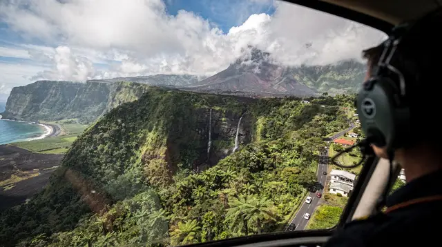
The Wild South is not a single site. It is a stretch of coastline between Saint-Joseph and Saint-Philippe where Piton de la Fournaise has repeatedly sent lava down to the ocean, leaving black basalt cliffs, cooled flows you can walk on, and a road that curves with the coast rather than cutting across it. There is no town centre to aim for and no lagoon to relax in. What you are driving out to see is the landscape itself: the point where the volcano meets the Indian Ocean.
That distinction matters when you plan the day from Saint-Gilles, on the opposite, dry side of the island. This guide covers the coastal loop through Saint-Joseph, Saint-Philippe, Cap Méchant, the puits arabe, a spice garden or two, and the Grand Brûlé lava fields, with an optional detour to the Langevin waterfall. Saint-Pierre’s market, nightlife and the Pierrefonds airport belong to a separate Saint-Pierre itinerary; the Anse des Cascades and the Notre-Dame-des-Laves church, further north on the windward coast, belong to the East Coast. Keeping the day focused on the lava coast itself is what makes it work.
Why this is a full day, not a half-day
It is tempting to look at the map, see Saint-Joseph and Saint-Philippe close together, and assume a quick out-and-back from the west coast. In practice, three things stretch the day:
- The road itself. The RN2 coast road between Saint-Joseph and Saint-Philippe bends constantly along the basalt shoreline. Kilometres on a map do not translate into minutes on this road, and speed limits reflect that.
- The drive from the west. Reaching the Wild South from Saint-Gilles or the Hermitage means crossing the island’s south, past Saint-Pierre, before the coast even turns lava-black. That drive alone is a meaningful chunk of the morning.
- The stops add up. Cap Méchant, the puits arabe, a spice garden, and the Grand Brûlé lava fields each deserve 20 to 40 minutes on foot. None of them is quick if you actually want to see them rather than photograph them from the car.
The honest way to plan this: leave Saint-Gilles early, treat the whole day as spoken for, and expect to be back in the evening rather than mid-afternoon. If your schedule cannot absorb a full day, this is not the right excursion to squeeze into a half-day slot — consider a shorter loop closer to the west coast instead, or check the driving guide before committing to the distances involved.
Getting there: the drive from Saint-Gilles
The most direct way to reach the Wild South from Saint-Gilles is to follow the coast south through Saint-Leu and on toward Saint-Pierre, then continue onto the RN2 coast road that becomes the Wild South route once the lagoon gives way to black basalt. Réunion drives on the right, and a rental car is close to essential for this loop: there is no train on the island, and the towns along this stretch sit too far apart for public transport to cover comfortably in a single day. If a car is not already arranged, the renting a car guide and the getting around Réunion Island guide both cover what to expect before committing to a route this long.
Fuel up before leaving the west coast rather than counting on finding a station along the way — options thin out noticeably past Saint-Joseph, and running low on a winding coast road with limited passing space is not where you want to test the gauge.
The route, stop by stop
Saint-Joseph: the gateway to the Wild South
Saint-Joseph marks where the coast starts to change character, with basalt outcrops replacing the lagoon-fringed beaches of the west. It is a reasonable first stop for fuel, a coffee, or the inland detour to the Langevin waterfall (see below) before continuing along the coast toward Saint-Philippe.
The Langevin valley detour
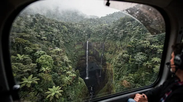
Inland from Saint-Joseph, a side road follows the Langevin river up to a waterfall and a natural swimming spot in fresh water, well away from the ocean’s swell. It is a worthwhile detour if your day genuinely has room for it — the water here, unlike the coast itself, is a place people actually swim. If the schedule is already tight, this is the first thing to drop; it adds real time and sits slightly off the main coastal line. Those who want the water and the adrenaline both can look at a canyoning outing on the Langevin river as a half-day activity of its own rather than a quick stop.
a guided canyoning descent through the Langevin river’s pools and waterfallsSaint-Philippe and the spice gardens
Saint-Philippe is a small, quiet town that serves as the practical midpoint of the loop. Nearby, one or two spice and vanilla gardens open their grounds to visitors, offering a slower, shaded contrast to the exposed lava coast on either side. This is also where the character of the road shifts from ordinary coastline to the volcanic landscape the Wild South is known for.
Cap Méchant
Cap Méchant is a viewpoint over black cliffs where the swell hits basalt hard enough to throw spray high into the air on a rough day. There is a marked path and a small parking area, but no beach, no lagoon, and no safe entry into the water anywhere near it. Stay behind the marked limits: the waves here are unpredictable and there is no lifeguard presence or rescue infrastructure on this part of the coast.
The puits arabe
A short walk from the road, the puits arabe is a natural rock formation where the ocean has carved openings into the basalt, sending water surging through at intervals. Like Cap Méchant, it rewards a careful, from-a-distance look rather than a close approach to the rock edge.
The Grand Brûlé and its lava flows
The Grand Brûlé is the lower, seaward flank of Piton de la Fournaise, where past eruptions — most visibly in 2007 — have sent lava all the way down to the coast, crossing and eventually reclaiming the road itself. Today the RN2 runs directly through solidified black lava fields on both sides, with marked paths letting you walk out onto the cooled flow. This is the visual high point of the day: an entire landscape built in a matter of weeks by an eruption, still bare of much vegetation decades later.
Seeing active lava is never guaranteed. Eruptions at Piton de la Fournaise are frequent by world standards but genuinely unpredictable, monitored by the OVPF-IPGP observatory, and the prefecture can close access to the eruption zone entirely without notice. Come for the landscape the past flows created, which is reliably there, not for a promise of lava that no honest guide can make. If the volcano is what draws you most, the dedicated Piton de la Fournaise guide and volcano tours from the west coast cover the crater side of the mountain separately from this coastal route.
What this day is not
Worth being explicit about, because the Wild South gets photographed in ways that can mislead:
- It is not a beach day. There is no supervised swimming anywhere on this coastal stretch. The ocean here is powerful basalt-cliff swell, not lagoon water. If you want sand and a swim, that belongs on a Saint-Gilles or Saint-Leu day instead.
- It is not Saint-Pierre. The market stalls, restaurants and nightlife that make Saint-Pierre worth a stop of its own sit further along the coast and are better treated as a separate outing.
- It is not the Anse des Cascades. That waterfall-meets-ocean spot and the Notre-Dame-des-Laves church, both spared by a past lava flow, sit on the island’s windward East Coast, not on this southern lava route.
Organised ways to see the Wild South
Self-driving gives you control over pace and stops, but the coast also lends itself to guided formats that add a different angle on the same landscape.
an off-road buggy circuit through the Wild South’s lava trails and coastline a guided day combining waterfalls, nature stops and the Grand Brûlé lava route a private day trip through the Wild South with waterfall stops built inFor travellers without a rental car, or who would rather not handle the winding coast road themselves, a guided option also removes the need to time the return drive against fading daylight — a real consideration given how much of the day this loop can take.
Planning your day: a realistic outline
| Stop | What it is | Time to allow on-site |
|---|---|---|
| Saint-Joseph | Gateway town, fuel and coffee | 15–20 min |
| Langevin valley (optional) | Waterfall and freshwater swimming spot | 45–90 min |
| Saint-Philippe & spice gardens | Small town, vanilla and spice garden visit | 45–60 min |
| Cap Méchant | Basalt cliff viewpoint, no swimming | 20–30 min |
| Puits arabe | Rock formation with surging surf | 20–30 min |
| Grand Brûlé lava fields | Walk on solidified lava, road through the flow | 45–60 min |
Add the drive time from the west coast on both ends, and the honest total is a plein day: leave Saint-Gilles not long after sunrise, and expect the return drive to finish after dark for part of the year.
When to do this drive
Réunion’s seasons run opposite to Europe’s, since the island sits in the southern hemisphere. The dry, cooler austral winter (May to October) is the more reliable stretch for a long driving day like this one: less rain on the exposed coast road, and generally calmer conditions for the viewpoints at Cap Méchant and the puits arabe. The austral summer (November to April) is also the cyclone season, when heavy rain can affect visibility and road conditions on this kind of coastal route, and the prefecture can close sections of the Wild South, including parts of the Grand Brûlé, with little notice. Check the weather by month guide when picking dates, and if your trip falls between November and April, read what a cyclone warning during your trip actually means for a day like this one before locking in a date.
Before you go
- No swimming gear needed for the coast itself. Bring it only for the optional Langevin detour.
- Sun protection matters more than it looks. There is little shade along the lava fields and viewpoints.
- Fuel up before Saint-Philippe. Options thin out along the Wild South stretch compared with the west coast towns.
- Check road conditions before leaving. Heavy rain can affect sections of this coast road; a quick check the morning of your trip avoids surprises. The travel mistakes to avoid guide covers this and other planning slip-ups.
- Pair it wisely. If you also want Saint-Pierre’s market or the East Coast’s Anse des Cascades, give each its own day rather than folding them into this one — see the two-day Wild South and East Coast itinerary for a version that does both properly.
- The euro is the currency. Réunion is a French overseas department, so travellers coming from mainland France or elsewhere in the EU need no currency exchange for this trip.
- No tipping expected. Service is generally included at the stops along the way, so there is no need to budget extra for it.
Frequently asked questions about the Wild South day trip
Is the Wild South a place to swim?
No. This coast is black basalt shaped by lava flows, with heavy swell and no supervised swimming zones along the route. Bring water and a hat, not a swimsuit for this particular stretch.
How long does the Wild South loop from Saint-Gilles actually take?
Longer than the kilometres suggest. The coast road between Saint-Joseph and Saint-Philippe curves constantly, and every stop (Cap Méchant, the puits arabe, a spice garden, the Grand Brûlé lava fields) adds 20 to 40 minutes. Plan a full day, from soon after sunrise to early evening.
Should I combine the Wild South with Saint-Pierre or the Anse des Cascades in one day?
Not comfortably. Saint-Pierre’s market and Pierrefonds airport sit on a separate itinerary, and the Anse des Cascades and Notre-Dame-des-Laves church further north belong to the East Coast loop. Trying to fold either into the same day usually means rushing the lava coast itself.
What is the Grand Brûlé exactly?
It is the stretch of lava field on the southeastern flank of Piton de la Fournaise where past eruptions have flowed down to the sea, most visibly in 2007. The road crosses solidified black lava on both sides, with marked paths onto the flow itself.
Can you see lava on this drive?
Only if an eruption is active and the prefecture has not closed the area, which is never guaranteed. What you will reliably see is the solidified lava field and coast the past flows created — an honest, still striking sight on its own.
Is the Cap Méchant coastline safe to walk?
The marked viewpoints and paths are fine on foot, but stay back from the cliff edge and out of the water. Waves here are unpredictable and there is no supervision or rescue infrastructure on this stretch.
Do I need a 4x4 for the Wild South road?
No, a standard rental car handles the coastal road (RN2) between Saint-Joseph and Saint-Philippe without issue. It is the driving time from bends and stops, not the road surface, that eats the day.
Is the Langevin waterfall worth the detour?
If you already have a full day, it is a reasonable add-on inland from Saint-Joseph before continuing to the coast. If your day is already tight, it is the first thing to cut without losing the character of the trip.
Trip planning tours and activities on GetYourGuide
Verified deep-linked GetYourGuide tours. Book through these links and we earn a small commission at no cost to you.
GetYourGuide does not provide a product photo for this activity — the image shows the meeting point, photographed by us.